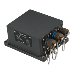
How OCTANTIS INS enabled precise navigation and real-time positioning for unmanned ground vehicles operating in hazardous underground mines.
- Client
- An earthmoving and mining equipment manufacturer
- Site
- Underground mines and tunnels
- Industry
- Land Systems
- Result
- The UGV navigated reliably without GNSS, so no one has to enter the hazardous zone.
Background & Operational Challenge
Our customer, a premier earthmoving and mining equipment manufacturer, initiated the design and development of a remotely operated Ground Unmanned Vehicle (UGV) capable of performing inspection missions in dark, confined underground environments. Within tunnel systems, GNSS signals are often weak, partially available, or completely unavailable due to signal attenuation and obstruction.
The requirement was to deploy an autonomous UGV capable of:
Precise positioning in GNSS-denied environments
Stable real-time orientation for vehicle control
Accurate geo-referencing of captured images and videos
Reliable navigation without human presence in hazardous zones
A mission-critical sensor was required to provide continuous Position, Navigation, and Timing (PNT) data along with real-time attitude (roll, pitch, heading) information to ensure vehicle stability throughout the inspection route. The solution needed to be field proven for land systems, exhibit minimal drift during GNSS outages, be ruggedized for harsh environments, and remain cost-effective.
Solution Overview
Aeron Systems deployed its OCTANTIS (OCT3-NS7700T) MEMS-based Inertial Navigation System as the primary navigation core of a ground unmanned vehicle designed for mine and tunnel inspection. The UGV was equipped with camera and video payloads while OCTANTIS ensured continuous, reliable navigation across open-sky, GNSS-degraded, and fully GNSS-denied environments.
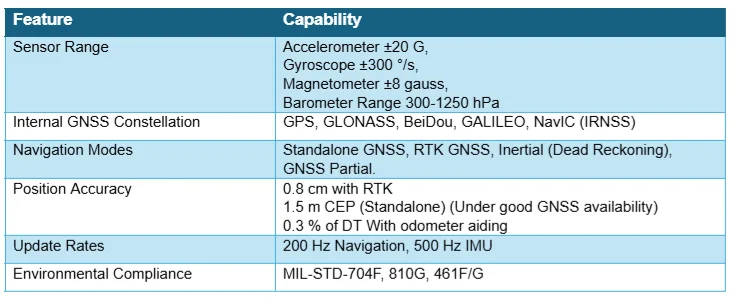
The OCT3-NS7700-HP is a dual-antenna high performance MEMS INS-GNSS system designed to provide highly accurate and reliable navigation and orientation data for a range of mission-critical applications. It includes an integrated high-end tactical grade MEMS-based inertial measurement unit (IMU) with 0.25°/h bias instability and a dual-antenna GNSS receiver, allowing the system to determine true heading independent of motion or magnetometers.
The system employs advanced Kalman filtering to combine inertial and satellite data, enabling seamless transitions between GNSS-available and denied scenarios.
OCTANTIS INS Key Capabilities
Operational Flow
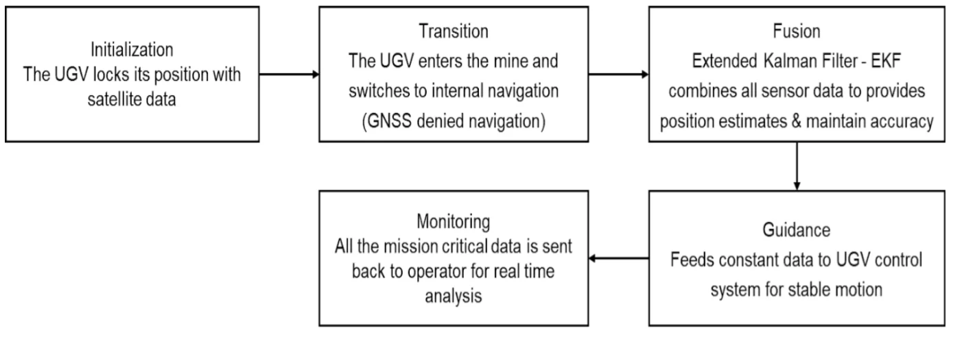
In open-sky regions, OCTANTIS operates in RTK/GNSS mode, providing centimetres to meter-level position accuracy and precise heading for mission initialization and mapping.
As the UGV enters tunnel or mine environments, GNSS availability degrades or is lost. OCTANTIS automatically transitions to pure inertial navigation mode. In the pure inertial mode, the Octantis INS takes input from the onboard wheel odometer which aides the navigation by correcting and suppressing the drifts that arise due to gyroscope instability.
The onboard Kalman filter fuses inertial sensors, magnetometer data, wheel odometer data and intermittent GNSS (if available) updates to bridge outages and suppress drift.
Continuous position, velocity, and attitude data are supplied to the UGV control system, enabling stable autonomous motion and accurate geo-referencing of video and images.
Mission data is transmitted to the operator station for real-time monitoring and post-mission analysis.
An assured real time PNT data is provided to the UGV control system and the operator using OCTANTIS sensor.
Operational Impact
The deployment of OCTANTIS INS enabled complete removal of human presence from hazardous inspection zones, significantly reducing risk and preventing loss of life. The system demonstrated reliable navigation performance in GNSS-denied and degraded environments, validating OCTANTIS as a mission-critical navigation solution for unmanned ground systems operating in extreme conditions.
This case study highlights Aeron Systems’ capability to design and deliver indigenous, high-performance MEMS-based inertial navigation systems for autonomous and safety-critical applications.
OCTANTIS INS proved to be a rugged, field-ready, and cost-effective solution for unmanned mine inspection vehicles, supporting defence, homeland security, and industrial autonomy missions requiring assured navigation in GNSS-denied environments.

Disclaimer : Images used in this article are for representative purposes only. No copyright infringement is intended, and credit is given to the respective owners.
Author : Karan Retawade | Sr. Sales Engineer